Transit, especially rail based, requires large numbers of people travelling to one central destination. In Victoria we have had Downtown as a major daily destination for years, but is it realistic to expect that to continue into the future?
As far as I can see, the amount of new office space downtown is not dramatically increasing, but the focus on a lot more housing close to downtown is reducing the demand for transit as more people are walking. One only needs to look at what has happened in downtown Portland and see that the total number of jobs is not rising and that the biggest rise in commuting is with walking and biking, the demand for bus and rail transit is falling. I know, I am linking to Randal O'Toole, even if you do not like his politics, he has a lot of good data.
In the last generation we have seen almost all the retail jobs created outside of Downtown. We have also seen the loss of almost all the blue collar industrial jobs leave the Downtown area. Government jobs are also moving away from the Downtown core, Selkirk Water has a number of ministries located there.
The nature of where the jobs are in this region is changing. Keating Cross Road has a many more jobs than a generation ago, many of them formerly from Downtown. The interurban Camosun college and the tech park are also a new work destination. It was longer ago, but VGH used to be downtown before moving out to Helmeken. The big box cluster in Langford and the Westshore shopping centres are now major centres for employment.
The changing pattern of where we are working means we will need a very flexible transit system. Ideally a lot of bus routes going to many destinations with the operator using different sized buses based on demand.
As we encourage walking and biking, we are pulling people out of the transit stream. I have no proof of this, but anecdotally most of the people I know that bike or walk to work used to bus to work.
Finally, another big change to the nature of work, working from your own home. I do not need to use transit to commute because I work from my own home. All the time more and more people are doing this. This trend is not going to increase the number of commuters.
The nature of the future of work does not bode well for ever having a business case for rail based transit in this region.
Saturday, July 31, 2010
Sunday, July 25, 2010
Some more pics of details from the new Uptown Centre
 |
| Detail from the wall near WalMart |
I thought I would post some pics I took the other day of the details on the buildings and such.
 |
| Near the southern entrance to Uptown Boulevard |
 |
| This is the base of the lamp standards on the Shoppers level |
Thursday, July 22, 2010
The New Uptown Centre


Issues I noted today:

- there are only 27 parking spots on Uptown Boulevard, there will be more later but there are still not a lot on the main streetscape. The street is only one lane and will be stuffed up with cars as people to try and park
- there is only one elevator going from the Shoppers Drugmart level down to Walmart or the parking under Walmart. This will be a problematic issue because of the demand to access the elevator on all levels.
- the traffic patterns going in from Oak into the site are going to be a problem as there are multiple directions people want to go and they need to turn left across traffic flows. This will be an utter nightmare during anytime there is a lot of traffic. I can see a lot of problems with cars being able to even get around within the underground parking
- access up the the Shoppers level is decent from Blanshard, but getting out is not going to be great because of the traffic on Blanshard.
- there is no easy access to the underground parking from Uptown Boulevard
 |
| You can see the legislature from the parking lot at Shoppers Drugmart |
 |
| Cool effect looking through to Macdonalds |
The Shoppers Drug Mart is big and airy but offers little or nothing that I need that I do not get at the Shoppers at the Gorge - Tillicum plaza where all my prescriptions are. About all they seem to have is more food stuff and are open 24 hours a day. I suspect I will make use of this as there prices are reasonable and they are close to my home.

I went to the new WalMart the other day and I was underwhelmed, you can find my full set of thoughts here. Basically it is does not seem to improve on the old one for what it did provide previously and the grocery section is the worst in Greater Victoria and not particularly cheap. They really eliminated almost any reason to shop there.
Best Buy and Futureshop, I have never shopped at either one and can not think of a reason to go into them. I am not sure there will be many retailers on site that will draw my business. Certainly with the problems the traffic will be, I do not expect to enjoy driving in there.

On the Blanshard street side you have a Millstream Road outlet mall type of place with largish stores you park in front of. It is very much separated from the "Mainstreet" down below. there is only one access point from one to the other. I had not really thought about this and was lulled by the fly through images. Will people walk down the stairs to get from one to the other?

The fly through video spends almost half of its time on the central green space courtyard. It looks nice in the video, but is it really going to that nice in reality? Having been on the site recently, it is a much smaller area than one would think.
Uptown is better than the previous Town and Country, but it does feel like it missed the mark of what should be happening on that site. Seeing the reality of the development, it really is disappointing.
Tuesday, July 20, 2010
BC Transit Surveying businesses about rapid transit into Downtown
From Vibrant Victoria I see that BC Transit is going to all the business and landowners near Douglas, Blanshard and Government to ask them about their thoughts on a rapid transit corridor. Here is what is on their website:
I am assuming fiscal sanity continues to prevail at BC Transit and that they will put forward bus rapid transit as the best option for our needs and for our wallets. Certainly the recent E&N study does not indicate that there is a lot of potential demand for rail transit. Going forward with bus rapid transit means that the system has the highest degree of flexibility as to route.
I can predict some of the answers they will get - businesses will push to have it not on their street, they will also push for no loss in parking or access to their businesses. The answers are predictable, the question is what will BC Transit do with the responses they get?
From a business perspective, rapid transit along Blanshard makes the most sense, though for access to the Westshore I am not sure this is the best route. BC Transit will have to consider the strong message they get from business to put rapid transit on Blanshard and how they will address this.
A Blanshard route would require some way to shift the buses from Blanshard to Highway #1. There would have to be some sort of an bus overpass to get transit eastbound across to Ravine Way and then onto Blanshard. Downtown there are issues as well. At which point do you shift over to Douglas, at Pandora?
Really the system only works if there is a way for buses to avoid the long lines in and out of town, it is only jumping those queues that bus rapid transit makes any sense.
It is doable and will be hard to dismiss as a route if you get the strong reaction from the business community that I expect. If really does not work, a bus rapid transit system can be shifted much more easily than any rail based system.
One final aspect that needs to be considered in general with respect to rapid transit and rail based transit, the route BC Transit is looking at versus where the E&N is. The decision to develop a route from Langford to Downtown via Uptown means there will never be a case for rail based transit on the E&N.
Uptown-Downtown Alignment Issues & Opportunities – July 2010
BC Transit is undertaking a survey to better understand the implications for businesses of establishing a rapid transit system connecting Victoria to the West Shore via Douglas Street. This survey, developed in cooperation with the Greater Victoria Chamber of Commerce, Association of Douglas Street Businesses, Downtown Victoria Business Association and the Canadian Federation of Independent Business, is being conducted this month by Victoria-based R.A. Malatest and Associates. The survey will interview businesses and their customers on Douglas Street between Uptown and Downtown, as well as those that might be affected by a Douglas/Blanshard or Douglas/Government couplet or loop arrangement.
I am assuming fiscal sanity continues to prevail at BC Transit and that they will put forward bus rapid transit as the best option for our needs and for our wallets. Certainly the recent E&N study does not indicate that there is a lot of potential demand for rail transit. Going forward with bus rapid transit means that the system has the highest degree of flexibility as to route.
I can predict some of the answers they will get - businesses will push to have it not on their street, they will also push for no loss in parking or access to their businesses. The answers are predictable, the question is what will BC Transit do with the responses they get?
From a business perspective, rapid transit along Blanshard makes the most sense, though for access to the Westshore I am not sure this is the best route. BC Transit will have to consider the strong message they get from business to put rapid transit on Blanshard and how they will address this.
A Blanshard route would require some way to shift the buses from Blanshard to Highway #1. There would have to be some sort of an bus overpass to get transit eastbound across to Ravine Way and then onto Blanshard. Downtown there are issues as well. At which point do you shift over to Douglas, at Pandora?
Really the system only works if there is a way for buses to avoid the long lines in and out of town, it is only jumping those queues that bus rapid transit makes any sense.
It is doable and will be hard to dismiss as a route if you get the strong reaction from the business community that I expect. If really does not work, a bus rapid transit system can be shifted much more easily than any rail based system.
One final aspect that needs to be considered in general with respect to rapid transit and rail based transit, the route BC Transit is looking at versus where the E&N is. The decision to develop a route from Langford to Downtown via Uptown means there will never be a case for rail based transit on the E&N.
Since a few hundred of you read this most days.....
 I thought I would take a moment to shill for my oldest son Daniel.
 He wants to earn enough money to be able to go to Canadian Yearly Meeting of the Quakers. This is in the third week of August in Winnipeg this year. He wants to travel via Saskatoon to meet up with a couple other 15/16 year Quaker youth going to Winnipeg. Daniel feels a strong connection to the national gathering because of the youth that come from across the country to be there each year.
The picture is of him using the zipline in Robson Square during the Olympics - he is the one on the right. He had the patience to wait for hours to ride the line.
Daniel is looking for odd jobs this week and the first week and half of August.
He is 15, works hard in the garden and is smart enough not to need a lot of supervision. He can do garden jobs well. He is also a good researcher, I had him do some GIS based research for me and he did better than people with university degrees, if I had more research work to be done, I would get him to do it for me.
If you are interested, call Daniel at 250-298-7501, this is my home number.
Monday, July 19, 2010
City of Victoria Parkades
The City of Victoria owns or operates five parkades in downtown Victoria. Oak Bay, Saanich and Esquimalt do not have any. Time to ask why the City is in the parking business at all and if it were not better for all of us if they sold the parkades.
These are the City Parkades:
Let us ignore the one under the downtown library and look at the other four. These are properties the City owns and have been left underdeveloped for some decades now. Not only that, as long as the City owns them, they do no produce property taxes. Finally, the City is not in the business of running a parking business, this is better done by the private sector.
If one were to sell the four stand alone parkades to someone like Robbins or Impark, the City would free up a lot of capital that is tied up in providing the parking and bring in significant property taxes, this assumes no redevelopment of the sites. If one were to redevelopment with site appropriate development, Downtown would have more office and retail space and the City would collect even more in property taxes.
The View Street parkade is 2/3s of an acre in size and covers 100% of the lot. The parkade detracts dramatically from the look and feel of the street. Given the heights of the buildings around it, it would be reasonable to build a 10 story building on this site. Build with it an underground parkade going down five floors and you go replace most of the parking that would be lost.
Much the same can be said about the Johnson Street Parkade, though in this case I believe that a redevelopment could work to make the streetscape much more inviting and help revive the fortunes of the block and help build another connection for the flow of people in the downtown.
The Bastion Square or Yates Street parkade is an extreme eyesore in the location where it is. It actively harms tourism by being so freaking butt ugly in the middle of the Old Town. The City should seek out someone willing to build something that blends in with the period and provides a walk through connection from the back side of the Maritime Museum to Yates Street.
The parking in the Yates Street Parkade is very important for Old Town, any new development should provide as many parking spaces or more. The building foot print is 0.38 acres, but next to it there are two spots the City could consider allowing underground parking to expand in to. First is the courtyard, digging under it would all another 0.09 acres of space for parking. Second, if the City allowed an underground parkade to extend under Langley street, this would add another 0.1 acres. The working area would then be 0.57 acres, or 50% more than now. This would allow the same parking that is currently available in four floors underground.
What sort of building makes sense on the site? I would think a 7-8 story condo development with ground floor retail. This would be something in the order of 70 units. Since the City currently brings in no property taxes, giving a ten year tax holiday to encourage the development would not make a difference to the City bottomline.
The Centennial Square/Fisguard Parkade could be packaged together with the two buildings next to it on Douglas Street. This site would a total of be close to an acre and is currently woefully underused. The City archives needs a new home and could be accommodated in a new building. Seven to eight floors would be in keeping with the look and feel of the area. With the new Hudson development and the office building on the south east corner, something on this site would pull Downtown up the street some more.
Fisguard would also benefit from this because there could street level life on a stretch of 75 metres that at the moment is dead space. Building that would make a better connection to and from Chinatown.
The City also has a number of surface parking lots that it owns
Of the surface lots, most of the ones the city owns make little or no sense to change, but two of them should be considered for some sort of redevelopment.
The lot at the corner of Blanshard and Courtney behind the theatre is just about a 1/4 acre in size and it provides parking for 40 cars. The property could easily be redeveloped with a five story office building on it with ground floor retail and three floors underground for parking. This would provide about 5000 square feet of retail, 25,000 square feet of office space, and 90 parking spots.
The Caledonia parking lot is a large waste of space at the moment, it is not used for nearly as much time per day as it should be to justify it as a parking lot. Currently it is 1 2/3s acres of land providing parking for about 230 cars. The area of Vancouver Street which runs between the parking lot and Royal Athletic Park is another 1/3 of an acre. This short section of Vancouver Street has no one depending on it for anything, I should be removed and made better use of. It strikes me as a good location for a public market. How would I configure it? I am not sure, I am aware there needs to some sort of parking continue to be available
The sale of these property should bring the City significant amounts of money, enough to take on some the capital infrastructure projects that need urgent attention. It will also increase the tax base by enough to make a noticeable difference in the budget.
These are the City Parkades:
- Bastion Square
- Centennial Square
- Johnson Street
- View Street
- Broughton Street - I am not certain they own this parkade, they may simply operate it.
Let us ignore the one under the downtown library and look at the other four. These are properties the City owns and have been left underdeveloped for some decades now. Not only that, as long as the City owns them, they do no produce property taxes. Finally, the City is not in the business of running a parking business, this is better done by the private sector.
If one were to sell the four stand alone parkades to someone like Robbins or Impark, the City would free up a lot of capital that is tied up in providing the parking and bring in significant property taxes, this assumes no redevelopment of the sites. If one were to redevelopment with site appropriate development, Downtown would have more office and retail space and the City would collect even more in property taxes.
The View Street parkade is 2/3s of an acre in size and covers 100% of the lot. The parkade detracts dramatically from the look and feel of the street. Given the heights of the buildings around it, it would be reasonable to build a 10 story building on this site. Build with it an underground parkade going down five floors and you go replace most of the parking that would be lost.
Much the same can be said about the Johnson Street Parkade, though in this case I believe that a redevelopment could work to make the streetscape much more inviting and help revive the fortunes of the block and help build another connection for the flow of people in the downtown.
The Bastion Square or Yates Street parkade is an extreme eyesore in the location where it is. It actively harms tourism by being so freaking butt ugly in the middle of the Old Town. The City should seek out someone willing to build something that blends in with the period and provides a walk through connection from the back side of the Maritime Museum to Yates Street.
The parking in the Yates Street Parkade is very important for Old Town, any new development should provide as many parking spaces or more. The building foot print is 0.38 acres, but next to it there are two spots the City could consider allowing underground parking to expand in to. First is the courtyard, digging under it would all another 0.09 acres of space for parking. Second, if the City allowed an underground parkade to extend under Langley street, this would add another 0.1 acres. The working area would then be 0.57 acres, or 50% more than now. This would allow the same parking that is currently available in four floors underground.
What sort of building makes sense on the site? I would think a 7-8 story condo development with ground floor retail. This would be something in the order of 70 units. Since the City currently brings in no property taxes, giving a ten year tax holiday to encourage the development would not make a difference to the City bottomline.
The Centennial Square/Fisguard Parkade could be packaged together with the two buildings next to it on Douglas Street. This site would a total of be close to an acre and is currently woefully underused. The City archives needs a new home and could be accommodated in a new building. Seven to eight floors would be in keeping with the look and feel of the area. With the new Hudson development and the office building on the south east corner, something on this site would pull Downtown up the street some more.
Fisguard would also benefit from this because there could street level life on a stretch of 75 metres that at the moment is dead space. Building that would make a better connection to and from Chinatown.
The City also has a number of surface parking lots that it owns
- 820 Courtney Street - Behind the Royal Theatre
- 900 Wharf Street - this is on the harbour and has benefits because it allows for a large open space on the harbour.
- 1300 Wharf Street - very few spots and all on monthly passes, the site is mainly a park
- 1600 Store Street - this is beside the E&N station and not very large
- 940 Caledonia Street - the parking for Royal Athletic Park
Of the surface lots, most of the ones the city owns make little or no sense to change, but two of them should be considered for some sort of redevelopment.
The lot at the corner of Blanshard and Courtney behind the theatre is just about a 1/4 acre in size and it provides parking for 40 cars. The property could easily be redeveloped with a five story office building on it with ground floor retail and three floors underground for parking. This would provide about 5000 square feet of retail, 25,000 square feet of office space, and 90 parking spots.
The Caledonia parking lot is a large waste of space at the moment, it is not used for nearly as much time per day as it should be to justify it as a parking lot. Currently it is 1 2/3s acres of land providing parking for about 230 cars. The area of Vancouver Street which runs between the parking lot and Royal Athletic Park is another 1/3 of an acre. This short section of Vancouver Street has no one depending on it for anything, I should be removed and made better use of. It strikes me as a good location for a public market. How would I configure it? I am not sure, I am aware there needs to some sort of parking continue to be available
The sale of these property should bring the City significant amounts of money, enough to take on some the capital infrastructure projects that need urgent attention. It will also increase the tax base by enough to make a noticeable difference in the budget.
Sunday, July 18, 2010
Making Transit more efficient in Victoria
The biggest problem we have in Victoria is the lack of serious Express Bus service.
1) Actually make some form of bu lanes on Highway #1 out to the Westshore. There is enough space on either side of the Mackenzie and #1 intersection and the Tillicum and #1 intersection to add an extra lane for buses only. During non peak times this could be the shoulder of the road.
You would not need the third lane going west past Mackenzie or going east past Tillicum.
Of course the lights at these intersections would be pus priority during peak times and would remain red till all the buses went through. There is no reason the buses could not have transponders to make this happen.
These changes should shave off about 5 to 8 minutes of the trip and make a a trip not 45 minutes, but 37 to 40 minutes. It also increases the capacity on the route by 10% without having to buy new buses.
Another change could be to route a new bus via Veteran's Memorial Parkway and then onto the Highway. This would speed up people getting from Langford into downtown, this would save another 5 to 8 minutes per trip in peak times.
2) Would it be so hard to replicate the B-Line buses from Vancouver here in Victoria?
One change that would need to have happen to make this work better is a machine to read your pass or ticket, something like is used in Vancouver.
Two routes that come to mind for me, both of them with the same end points, UVic and Dockyard.
The first would run from Dockyard to Admirals and them Mackenzie out to the University.
The second would run from Dockyard along Esquimalt Road and then up Fort and then Foul Bay to UVic.
The buses should be operated like the B Line ones in Vancouver, multiple entry for the public and you need should have your fare paid before stepping on the bus. This would mean having automated ticket machines at all the stops. It would also mean have ticket/pass readers on all buses, like they do in Vancouver.
If the bus can load quickly and spend less than 45 seconds at a stop, this would improve the speed. These buses should also be built with transponders that signal to the lights where they are at and make the lights more favourable for them.
Once again, these changes will increase the capacity of the system at no extra cost in buses. In fact putting in the B-Line type buses should free up the resources to offer 10,000, or more, service hours per year at no cost. This would be enough to offer something on par with the new #10 for no added cost.
The bus stops for these routes should have displays that show how long till the next three buses, and which they are and if they are full. Actually, Victoria Regional Transit should look at "Next Bus" displays for the top 10% of stops in the region. Knowing how soon the bus will be there will increase use.
Friday, July 16, 2010
Light Rail, what would it take to make sense?
In looking at different light rail systems through out North America, there seems to be a threshold of 100,000 passenger trips at which point light rail construction and operational costs come to a point of being economically sustainable.
Currently Victoria Regional Transit has about 96,000 passenger trips per week day, this is actually quite a high percentage of the population using transit and is a better result than many US cities with rail based transit. One of the biggest reasons we do not have higher transit use is because a very large portion of the public either walks or bikes to work. 16.1% of the people in the CRD walk or bike to work, in the City of Victoria it is 1/3.
Rail based transit goes in a line from point A to point B and needs to have significant populations needing to make use of the line. The two biggest destinations in the region are UVic and Downtown and both are destinations, is there any place you could gather enough people to make sense to transport them to either location?
The tree SkyTrain lines in Vancouver have more passenger trips per day than the total population of the CRD. This should give people an idea of the difference of scale between Vancouver and Victoria.
For comparison, UBC has 46,000 students and UVic has 19,000. UBC is located in such a way to force the vast majority of people to live at least 3 km away, UVic has a large percentage of the students living within 3 km. UBC does not yet have a rapid transit line out it even though there is a much higher demand than for UVic, though the latest plans speak of the idea of having a line out to UBC in ten years time.
SFU on Burnaby Mountain is comparable in size to UVic but is really not located within walking/biking distance for people to get to. There is no discussion of rail transit to SFU anytime soon. There is more of a demand and need for rail rapid transit in the lower mainland than here in the CRD.
Downtown is the other major destination in our region, but the public comes from a host of different directions to get there. The first SkyTrain line in Metro Vancouver runs from Surrey to Downtown going through an area with a population twice as large as Greater Victoria.
The one big point huge amounts of traffic passes through is the spot where Uptown Centre is, but is there enough traffic there to justify a rail link to either UVic or Downtown?
In Canada six cities have some form of rail based transit, they also happen to be the six largest in Canada. The smallest is Edmonton is three times the size of Victoria. Winnipeg, Hamilton, Halifax, London, Kitchner, St Catherine's and Oshawa are all larger than Victoria and all are located in places that do not allow for nearly as much walking and biking to work.
The LRT in Edmonton is one the smallest in Canada and it has 74,000 passenger trips a day. This is more than the total transit traffic in Victoria.
The O-Train in Ottawa is even smaller, it uses an 8km stretch of existing grade separated railway. It has a current daily passenger load of 13,600 but costs more per passenger to operate than the buses. Because the line is only 8km long and grade separated, the OTrain can get from one end to the other in less than 15 minutes. The OTrain also operates from 6:30 am to 12:30 am, 18 hours a day. It also operates on weekends. The OTrain does not move a lot of people but due to its configuration it is less costly to operate than most. We have no comparable location here in Victoria and would have to build anything like this from scratch.
Is there a location we could build an 8km long grade separated line that could take about 13% of our transit traffic? Clearly this could not be anything coming in from the Westshore and would have to be something replacing the busiest bus routes. Tillicum to UVic? Esquimalt Dockyard via Downtown to UVic? The cost to built these lines would be very, very expensive.
As far as I can see, there is no obvious location where there is enough traffic in our region that could support rail based transit. We may be decent users of transit, but we are still very far from the numbers needed to make any rail system work. As I said earlier, there is a unique impediment to increases in transit in this region, and this is the large number of people that walk and bike to work.
Why do we have to have the CRD?
I keep coming across more and more reasons to dislike the the CRD but all of these reasons come down to one fundamental issue - the CRD is not elected and is not accountable to the public. The CRD is an undemocratic body that has as much public legitimacy to make decisions in our lives as the federal Senate does.
The vast majority of the people who sit on the CRD board are not elected to be there by the public, they are chosen to be there by the councils they represent. There are a couple that are elected from the unincorporated areas and these are the only people that have any popular mandate to govern.
When someone is elected by the citizens to represent them on council, they have to answer for what they do there when they come the polls again - we can vote them out. On the CRD the board members do not represent any part of the electorate, but the municipality they are representing. The electorate that chooses them is the council. Some councils allow for some manner of public input into who would represent them at the CRD, but ultimately that decision is made by the council.
When someone is elected by the public, they have a fiduciary relationship with the public. They have a responsibility to act in the best interests of the public they represent. People that sit in the CRD board do not have this link but instead have a fiduciary responsibility to act in the best interests of the council that appointed them. A person from Oak Bay on the CRD board has to defend the interests of the Oak Bay council. The way the regional district board is chosen means we can never have decent and holistic regional governance.
What right does Saanich have to make decisions about Sooke when no on was given a popular mandate to make decisions about issues outside of their own municipality?
The CRD has a mass of staff that report to a board that is not elected by the public to make decisions or be accountable for their actions. The CRD can pass bylaws that interfere with our lives even though we have no right to decide who makes those decisions.
There needs to be a provincial reform of the regional districts, but in the absence of that there are some specific steps that can be taken in this region to bring us responsible regional governance.
Do not have the CRD pass any bylaws beyond the absolute minimum that is needed to function. Things like smoking bans, age limits on tanning booths etc... are examples of things that should be left to governments elected by the people, be that local, provincial or federal.
Get rid of anything the CRD does that does not need to be done by them. Parks, they should either be municipal or provincial, water should be dealt with by the local governments that make use of it, recreation should be handled by the local governments, environmental issues should left to the local governments, etc.....
Eventually move away from needing a regional district for anything by creating three municipal governments in the CRD and making each one of these take on the powers of a regional district. Fort Nelson has done this and is the only location in BC where the whole regional district board is elected by the public.
The public in Canada has a right to elect who governs them, anything other than responsible government is undemocratic and needs to ended.
Wednesday, July 14, 2010
Provincial government evaluation of the E&N corridor
The provincial government released their study into the E and N corridor and the results are not promising for people hoping that there will be any significant increase in passenger rail service of any sort. This is a quick overview and not meant to be a perfect reflection, just an analysis to highlight some of the issues for the line.
Here are the highlights:
Freight
The current use of the line is very low, less than 1,000 rail cars per year. Unless there is some major industrial activity that starts, the projection is for freight traffic to remain below 2000 rail cars. If the Raven coal mine opens this rises dramatically to in the range of 13,000 to 18,000 rail cars a year.
Even with the Raven mine opening, the rail line needs to move more like 35,000 to 40,000 railcars to justify the expense of the capital investments needed in the line.
The norm for freight services is that they make money or they are not offered. In the case of the E&N, more or less all of the capital costs for improvements of the tracks needs to come from freight services. This mean the means the freight services will have to bear annual debt servicing costs of around $7,000,000 to $8,000,000 a year. This adds $8000 to $10,000 to each freight rail car trip to recover the costs.
Intercity Passenger Service
Several options were evaluated which included looking at service to Port Alberni and adding more trains on the tracks. At the end of the day the total passengers moved per year came to 160,000 to 220,000 depending on the options considered, Currently 40,000 are moved each year.
The current service costs $2.2 million to operate and brings in $800,000 in revenue. Extrapolating to the possible passenger numbers, revenues rise to $3.2 million to $4.4 million. My estimate of the operating costs is that it would rise to something on the order of $4.4 to $6.6 million.
Passenger rail continues to need a subsidy to operate and can not provide any revenues to help defray the costs of upgrading and maintaining the system. The passenger service will need a subsidy of about $7.50 per passenger trip to be able to continue to operate.
The evaluation also looked at a tourist train operation and made estimates of 8000 to 13,200 with a revenue of $533,000 to $847,000 annually. A drop in the bucket and not enough to make any real difference in covering the costs of the railway.
Commuter Traffic Service
Option 1
Minimal service from Langford to Victoria. 13 km of track and four stations with
Option 2
Upgraded service from Westhills to Victoria 17.2 km of track with six stations.
Option 3
Upgraded service but also one trip per day from Duncan to Victoria
Passenger Demand
The evaluation did not find a lot of potential daily demand for commuter rail.
The minimal service would have an estimated 535 daily passenger trips or 133,750 annually.
The full service would have an estimated 1050 daily passenger trips or 262,500 annually
The Duncan option would have an estimated 1350 daily passenger trips or 337,500 annually.
For comparison, Victoria Regional Transit had 24,800,000 passenger trips last year and should be at least 35,000,000 in 2026. Commuter rail would only account for less than 1% of the total passenger traffic in the region.
Capital Costs
The minimal service of 13 km with four stations is estimated to be in the range of $70 to $130 million. The higher cost reflects the need for a lot of upgrading of level crossings along the route, I can not see a regular rail service being acceptable without much better level crossings. For this reason I will be using the higher number.
The expanded service with longer trains, six stations and 17km of service is estimated to be $90 to $166 million. The variation is once again related to the costs needed for level crossing upgrades.
One capital cost that was not considered in the evaluation is the cost to build rail over the Johnson Street bridge. This would add between $12 and $23 million to the cost of the line.
The Victoria Regional Transit Commission would have to take on a lot of debt to start the commuter rail service. If we assume that the capital costs are between $130 and $166 million and 2/3s of the costs are covered by the senior governments, this means $43 to $55 million of debt will have to serviced by the Transit commission. At the moment the VRTC has minimal debt servicing costs. Commuter rail will add debt servicing cost of around $3.5 million dollars a year. If the Johnson Street bridge costs are added, this raises it to around $4 million. All these assume 2/3s of the costs are paid for by a senior level of government.
Operating Costs and Revenues
The operating costs are estimated to be about $3.5 million a year for weekday service for 10 hours each day. This in current dollars. With 300,000 passengers trips in a year, this means the operating cost per passenger trip is close to $12 per passenger trip. In comparison, the existing bus network costs a $2.95 per passenger trip to operate.
The average fare that is brought in for each bus passenger trip is about $1.43. The subsidy for each passenger trip is $1.52.
If the commuter rail brought in about the same revenues per passenger trip, this mean a subsidy per passenger trip of about $10.50. With the cost of a bus pass for an adult being $80 and much cheaper for UVic and Camosun students, the assumption of revenues per trip seems reasonable. What this means is that each daily commuter would need a subsidy of $21 to cover the operating costs of the trip.
The debt servicing costs would add another $12 per passenger trip. In the end, the Victoria Regional Transit Commission will have a cost of about $48 per round trip commuter each day but only take in about $2.86 in revenues. This is a subsidy per commuter of over $10,000 per year.
Currently it costs the Greater Victoria Transit Commission about $90 million a year to operate the service. The commuter rail service would be 7.8% of the all the costs but only 0.9% of the demand.
One of the big problems with the commuter rail idea is that rolling stock is only used for a limited number of hours a day. The evaluation had each train set in use for seven hours a day and a total of 1750 hours a year. This is capital cost per rail car of $80 an hour for a 20 year lifespan
Final Comments
The rail line is reaching a point where if nothing is done to repair and rehabilitate the line, there will be no option but to close the line.
The capital costs involved are high, but even if they were free, the costs to operate the rail line are simply not affordable.
Tuesday, July 13, 2010
Vantreight Hill Project - the benefits
The project does have some significant benefits to the community, farming and the environment, here is a list of eight:
- Development is located in a location of low environmental impact. Much of the current new house construction in Central Saanich is on ALR land. Farms have been sold off as individual lots and many formerly farm fields now sprout houses. Adding this 57 houses will reduce the demand to build more houses in ALR.
- Consolidating six lots with a total area of 235 acres into 2 lots is the biggest single action to protect farmland in Central Saanich in more than a generation. One lot will be the second largest lot in the ALR in Central Saanich. These two lots will also have no subdivision covenants on them.
- 7.5 acres for community/allotment gardens. This is the biggest addition to new land for community gardens in this region in ages. This will make the idea of the Zero Mile Diet much more realistic for people.
- The 12 acres of the highest environmental values on the Hill will now be protected from any sort of development. 1.6 acres will be park as requested by Central Saanich.
- The farm will be able to be passed onto the next generation to manage, the fifth one.
- Several miles of walking and biking paths will be added allowing from better access from Dean Park to Saanichton.
- Half an acre of field currently paved with a road will be returned to field as the road access will no longer be needed.
- Central Saanich will see an increase in property taxes from the development but will have to provide almost no services to the development. A net financial gain for the whole community.
Some Pictures from the Hill Project location
I thought it would be helpful for people to see what the views from the Hill look like
The above is the view towards the greenhouses and warehouse of the Vantreights


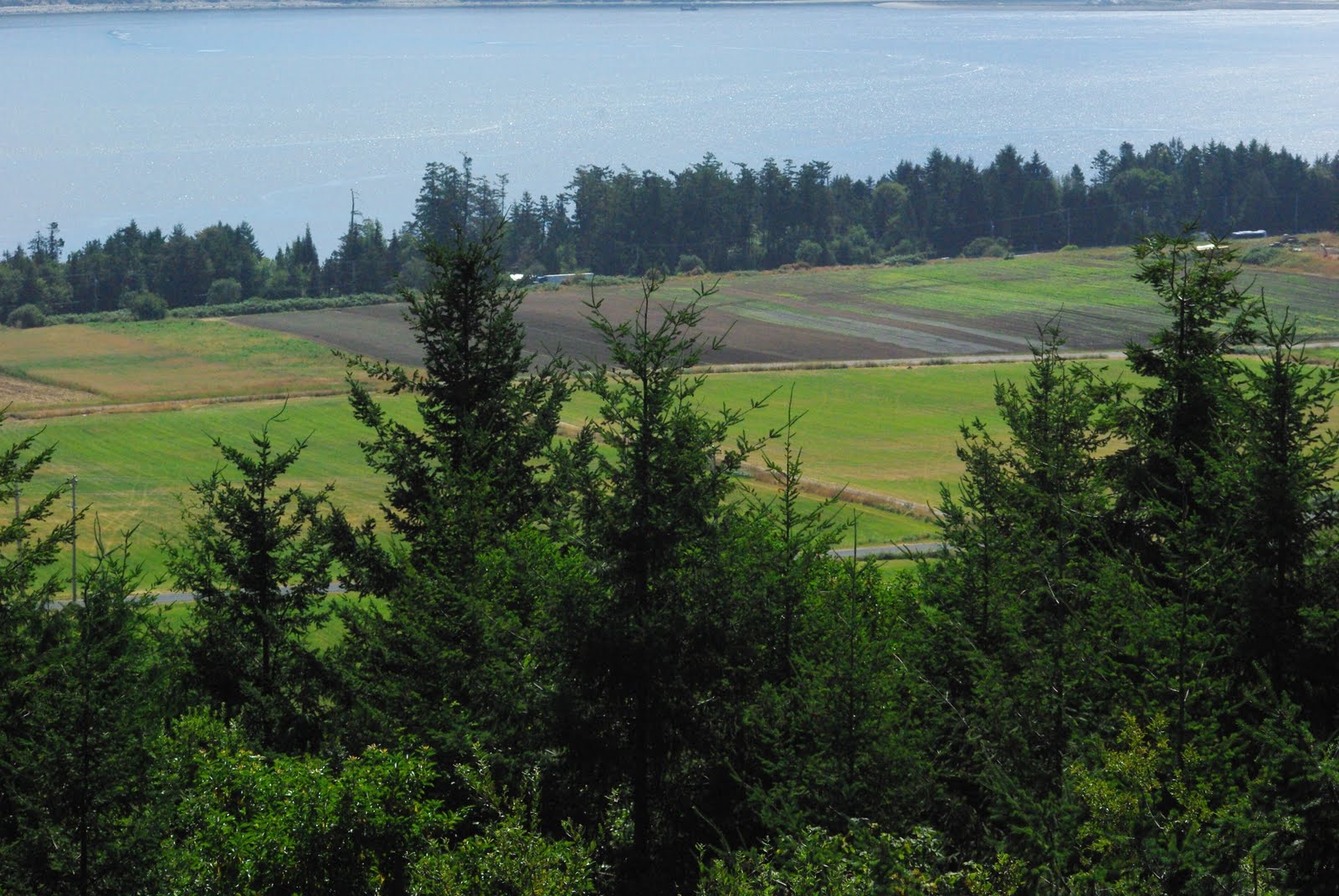


You can look towards the Olympic Peninsula from the Hill


On the right is a view of some of the rock and if you look closely some of the ground you have on the Hill - gravel. The Hill is one of the least productive pieces of land in the CRD and it also has some of the lowest environmental values.
Oak Bay Beach Hotel
Finally it looks like there will be forward motion on the hotel after a long delay. The TC reports that the Oak Bay council approved some zoning variances for developer Kevin Walker.
The neighbours have concerns about the changes as the whole development puts the hotel closer to the condo building to the south of the hotel. I can understand the concerns and remember some of the owners came to the property assessment review panel to get reductions in their assessments because of the impact of the construction and then the change in the impact of the hotel on their units.
I have been waiting for this development to move forward, though I doubt it will have anything like the Snug in the finished hotel. The location is a very good one for a high quality hotel and should be beneficial to more and higher spending tourism in the region. It also will pull more of the tourists out of the downtown core and move them to elsewhere in the region.
The old hotel was just a little too run down and tatty to really attract the sort of clientèle that is should have. The parking sucked.
What Oak Bay needs to consider doing now is looking at its waterfront and seeing how it can make better use of it. The location is a resource that should be put to much better use for the whole region. High end retail along Beach Ave. Allowing properties to be redeveloped into higher density but offering better public access to the water and more walkable area would all go a long way to building decent connection to the water.
Ideally Oak Bay Avenue should continue is some real way all the way to Beach. The continuation of the village all the way to the water would be helpful.
The hotel is a first step in making changes, the council should encourage the marina to develop their parking lot.
The waterfront and our disconnect from it in so many areas of Greater Victoria has been of concern to me. We really need to encourage better access and development along the waterfront that can not be used for industrial purposes. Oak Bay can and should take the lead on this.
Thursday, July 08, 2010
I am becoming a coastal wimp
I am amazed, there was a time when 40 degrees was fine by me and did not slow me down. Now I get a couple of warm days her in Victoria and I am vaguely annoyed that my house is too warm.
I admit that in Lillooet the 0 humidity was a factor in 40 degrees being bearable. We peaked at 32 degrees in this neighbourhood today but also had 33% humidity.
We are keeping our upstairs bedroom cool with two swamp coolers, though they are not working as well with the higher humidity. We bought two cheap fans at Home Depot today so we could get some more air movement in the house.
In the early spring we insulated the attic - it had almost nothing and there were spots were you could see daylight. Without this the upstairs would utterly unbearable, I have no idea how the people living here in the past managed to use the room.
The biggest problem in our house is that we have six of us and a dog in the house, we mammals add heat and humidity to the house.
The upside is that the garden is growing like crazy.
Wednesday, July 07, 2010
Vantreight HIll Project
The people opposed to the Vantreight Hill project say that it contravenes the Central Saanich OCP and the Regional Growth Strategy. I have read both documents from front to back and I can not find anything within them that says the Hill Project does not fit.
The OCP has as a first priority protecting farms and farmland - the proposal clearly does that. For Central Saanich to get six lots consolidated into 2 lots and have a no sub-division covenant is huge and is the single biggest act to protect farm land in Central Saanich since the ALR in 1974.
The OCP calls for no urban development outside of the urban containment boundary. The proposal is for a rural zoning that has been used before in Central Saanich and proposes a density that is seen elsewhere in rural Central Saanich. The rural nature of Central Saanich will not be altered because of this development.
I have looked in detail at the Dogwood Initiative site and the Residents and Ratepayers of Central Saanich and neither one has any details to explain why the current 57 house proposal is wrong.
Can anyone point out how the Hill Project contravenes the OCP?
The Bridge

There are open houses coming up:
Saturday July 10th 10am to 2pm Wednesday July 21st 6pm to 8pm
Though details of where, I assume at City Hall.
There is also a guided tour being offered in Saturday July 17th, though space is limited and you need to call 250-361-0288 to get a spot. No mention of what time of day, but I can not go in any case as I have offered to volunteer at Taste. I hope the have a few more tours, ideally I would love with Ross Crockford talking about the unknown history of the bridge.
I have to commend the mayor in getting the council to approach community engagement and input in a meaningful manner this time around. The last time it all felt like all the decisions were made and the public should just accept what was coming down the pipe.
What will the public reaction be? I have no idea.
My issue remains the same since the start - what will the final cost be and what certainty do we have this will not be exceeded?
Tuesday, July 06, 2010
Race for Victoria City Council
This is a very good chance for people to run and have the issues that are germane to the City of Victoria raised. Waiting till sometime after labour day is way to late to get into the race. People thinking about running need to be seeing how much money they can raise and who will support their campaign.
I know who I want to see run and I am having coffee next Thursday with someone considering running, but beyond that it has been quiet out there. I can get no sense who might run from the NDP camp or from the Green world. Both groups should be considering fielding someone, but if left too late they will have to run much harder than needed. If the VCE in 2002 and 2005 was any example of the energy of the NDP crowd, they need to be out there early and first to have any realistic chance of being in the race.
At this point Barry has been doing all the right things for the election and clearly would have to be seen as the front runner at this time. I am saying this not only because the is the only person in the race, but because he has clearly put a team together to back his candidacy. If he has a full set of volunteers in place by labour day and if he has shaken hands all summer, he will be several thousands of votes up on other people.
In most civic by-elections voter turn out is pathetically low, a lot lower than during the normal election. This time it is not likely to be that low as there will be a referendum on the bridge. Whatever the question is, there will be a much larger turn out at the polls. A higher voter turn out means that someone with a well known name could win the by-election without doing anything. I could see someone like Russ Courtnall winning in the fall on his name alone because of the higher turn out - in right of centre circles his name has been batted around as potential candidate for political office.
Monday, July 05, 2010
Some images of timber harvesting

These first ones are up along Kokisilah going towards West Jordan Main


These last two are on Butler Main close to the Bear Creek Resevoir


Saturday, July 03, 2010
Central Saanich and Agricultural Lands
I have been looking at Central Saanich and the farming lands there and here are some interesting facts:
In 1974 Central Saanich had 7292 acres of land in the ALR (Agricultural Land Reserve), now it is a 7183 acres. This is a loss of 109 acres in 36 years, or about 3 acres per year. A total loss of 1.5%
According to the 2006 Canadian Census 5510 acres of land in Central Saanich is being farmed - this has fallen by several acres in the last four years. I know of about 50 acres in the Martindale area that were being farmed five years ago are no longer being actively farmed. About one quarter of the ALR in Central Saanich is not being farmed in any way. Land is being lost to active farming because the new owners are not interested in farming.
There are about 57 lots in Central Saanich in the ALR area that are under one acre in size. Only 6 of them look like there might be any growing of food on them and then it looks like heavy gardening. These 57 lots have 57 houses on them and a total of 88 buildings on them. Quite a few of these houses are in excess of 8000 square feet in size. These houses on small lots in the ALR are a much bigger concern and cause a lot more issues with sprawl than one well thought out and contained development off of ALR or farmland.
There are several houses in Central Saanich on ALR that seem to be in excess of 20,000 square feet in size. The average sized detached house in Canada has an area of about 2000 square feet, these places ten times that size. If this were condo development, it could easily have 12-15 units in it.
Monster houses are not in keeping with the rural nature of Central Saanich.
The number of fulltime farmers in the region has dropped dramatically over the last generation. Protecting ALR has gone well in Central Saanich, but protecting farmers has not gone well.
I raise all this because of the heat the Vantreights are getting about their Hill project. They are proposing to build 57 houses on land that has never been farmed and will never be farmed. They are doing this to ensure the financial health of the farm. They are using an existing rural designation that is in keeping with the OCP and the Regional Growth Strategy. Meanwhile they are being attacked for the development.
Central Saanich does not seem to mind people buying farmland and then converting it into country estates. That is contrary to the wishes of the OCP and does nothing to protect farming or the rural nature of Central Saanich. If people in Central Saanich wanted to see the conversion of the remaining farm operations into rural estates, they should have raised that during the OCP process.
I have not even gone into what Central Saanich has allowed in rural areas outside of the ALR - more on that later.
Getting Stuck on Butler Main

This tale started on July 1st when I decided I wanted to go for a drive and see what was up the valley from Shawnigan Lake on the Old Port Renfrew Road. I had never been past the western side of the lake and I was curious what the Kokisilah valley looked like and where the roads went to. We were using the Backroad map book for the Island, one of the best off the shelf resources I have come across. It shows a nice network of roads the west of north of Greater Victoria, though most times these roads are behind locked gates because these are all private timberlands and not Crown Lands.

We saw some fresh logging as we were past the Kokisilah Provincial Park. The second growth in the area has reached a large enough size to be ready to be harvested. The logs are similar to what has been milled in the interior since the start of the forest industry. It also says to me that there is a long term future for forestry in this area.
If there is a mean annual increase in timber of 3 cubic metres per hectare, the area south of Lake Cowichan should be providing about 500,000 to 600,000 cubic metres of timber per year long term that is 12,500 to 15,000 logging truck loads a year. We still have a forest industry in this region that will produce enough work for 1000 or so people - this assumes no jobs in milling the wood, but that is the end of the business where there are fewer and fewer jobs anyway. Jobs have increased in trucking, harvesting, planning and silviculture.
We drove till we got to a point where we could take a road to the right and end up over at Lake Cowichan, continue straight towards Port Renfrew, but I knew this road did not go through, or go left and head along the West Jordan Main over the mountains to the Jordan River area. We decided on this last option. We were also doing this in our Mazda 5 and not in the truck, but I have always taken regular cars deep into the woods on logging roads and never had a problem because of the road, only because of the quality of the car or some dumbass move I decided to do.

We looked for the Jordan Meadows as they should have been along the side the road, but we saw little evidence of them. I would have taken more pictures, but the sky was overcast and the lighting was not very interesting. The long shots all looked washed out and 2D.

I should add here that the accuracy of the mapbook as clearly not as good as I had hoped. It was not because they made mistakes in making the mapbook, but it was becuase there had been changes to the roads since the book came out. What were on was clearly the West Jordan Main and remained so till we reached the bridge taking us over to what is now Butler Main - neither one of these names were the ones in the mapbook for the road at this point.
The mapbook worked well till the bridge that crossed the river, it was then that we started to run into problems.

At this point we ran into Dieter and Ashley of the Birds of a Feather B & B on Esquimalt Lagoon. They were out there in their bright yellow H3 looking for interesting tours for their guests. We ran into them a few more times.
I should have realized something was significantly different because the name Butler Main was on the road. I know Butler Main from the Sooke end and knew it did not go all the way up this way in the past.
We did not look too closely for the Jordan River Road because I wanted to first drive over and see the earthen dam for the Bear Creek Reservoir. We got to the location, but the sight lines sucked and the access from Butler Main to the dam had been removed.
At this point we both sort of began to wonder about the Jordan River road, we thought we should have passed it by now, but put it down to not reading the map correctly. We passed over the Jordan river bridge again and ended driving along what turns out to be Walker Main and it was no longer going through. We then doubled back and to Butler Main and searched for the road. We talked with Dieter and crew at this point and realized that the roads were not longer connecting as they used to.
Since we were on Butler Main and I knew were it ended, I thought we could drive down to the end. If the gate was locked, there was a moderate change that Willy at Camp Barnard would have a key. Along they way we were going to try and get over to Anderson Main as Dieter said they have been able to access it from the south side. We did consider that it might be getting late and we might end up behind the gates on West Jordan.
The first short road that should have connected Butler and Anderson was dug up. The second one that should have taken us to Tugwell Lake was nowhere to be found at all.
We reached the end of Butler Main and the gate was locked, our car parked only metres from Young Lake Road and freedom. We walked into the camp and found out that he did not have a key.
We got back to our car and found Dieter there. We all decided that we now had to drive back the way we came. Dieter was some way ahead of us and not at the gate that was closed 31 km up the road. We had no idea where they were. We heard from them later and they told us that they were able to drive around the gate with the H3, something we could not have done in the Mazda.

While we were waiting, we interacted with some llamas. Max fed them and Louie did not know what to make of them at all.
We were home by about 9 pm, much later than planned and much more tired. We also knew the next morning we had to go out and see if we could get the car out. We assumed that someone would be working on the Friday - wrong, they had all worked on the 1st so that they could take the Friday off.
I was out there and looking for ways out and waiting for people for a very long time. The car is still out there and we will either be able to get a hold of someone in Sooke with a key to the gate or have to go out on Monday when people are back at work.
Subscribe to:
Posts (Atom)